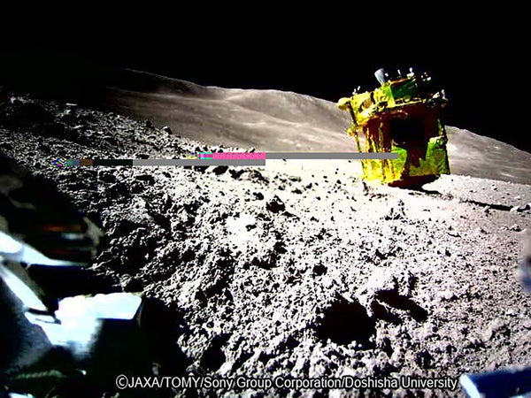
When Japan’s solar-powered SLIM spacecraft made a lopsided-but-successful touchdown on the moon in mid-January, most news coverage focused on the feat as a historic first for the nation—only the fifth after the U.S., the former Soviet Union, China and India to ever achieve a soft lunar landing. But the most historic aspect of SLIM—which stands for Smart Lander for Investigating Moon—wasn’t the mere fact of its landing but rather its remarkable circumstances. Designed by the Japanese Aerospace Exploration Agency (JAXA), the mission used autonomous navigation to demonstrate an unprecedentedly precise landfall in unusually treacherous lunar terrain, coming to rest close to the center of its boulder-strewn and crater-pocked target site despite losing one of its two main engines during its descent.
The landing is a milestone in lunar exploration that will undoubtedly lead to more as future missions use lessons from SLIM to pull off precise landings of their own to quickly access points of scientific or technological interest upon touchdown.
“With SLIM we demonstrated that accessing specific spots of scientific interest on the moon can now be done with small missions, too, instead of having traditional, more expensive missions deliver large rovers that drive long distances to reach desired areas,” says Masaki Fujimoto, deputy director general of JAXA’s Institute of Space and Astronautical Science.
On supporting science journalism
If you're enjoying this article, consider supporting our award-winning journalism by subscribing. By purchasing a subscription you are helping to ensure the future of impactful stories about the discoveries and ideas shaping our world today.
A Lunar Bull’s-Eye
SLIM’s achievement is best understood via what engineers call the “landing ellipse,” which is the area inside which a spacecraft is expected to touch down. In an ideal world, a lander would reach the center of this ellipse, which is advertised as the target landing site. In reality, even minuscule errors in navigation, guidance and control make it a near certainty that landers will miss this mark. A lander’s distance away from the ellipse center defines the achieved precision.
JAXA set an ambitiously tight landing ellipse of 100 by 100 meters for SLIM, and the spacecraft managed to touch down about 55 meters from its center. This makes SLIM the most precise planetary landing in history by a considerable margin. The runner-up is China’s Chang’e 3 lander, which in 2013 landed some 90 meters off-center from its landing ellipse; but Chang’e 3’s landing ellipse also spanned an area 3,600 times as large as that of SLIM, notionally giving the Chinese spacecraft vastly more room for error—a distinction that matters for mission planners.
“Precision landings allow you to reliably study more rock and soil types by planning an optimal touchdown point. This way you can land in, say, an impact-melt region and then drive over easily to a mare basalt,” says Benjamin Farcy, a postdoctoral researcher at NASA’s Goddard Space Flight Center. “Without precision landings, a typical rover with a range of a kilometer might not cover both lithologies.”
Seeing Is Succeeding
At the heart of SLIM’s precision-landing ability is a technology JAXA calls “vision-based navigation.” To determine its location and trajectory during its descent, SLIM snapped images of the moon’s surface for near-real-time comparison with orbital maps preloaded in its memory. These maps come from NASA’s Lunar Reconnaissance Orbiter (LRO), the Indian Space Research Organization (ISRO)’s Chandrayaan-2 orbiter and JAXA’s own SELENE craft. Each set of maps offered its own advantages for different phases of SLIM’s descent. For example, Chandrayaan-2’s Orbiter High-Resolution Camera (OHRC) offered the highest spatial resolution and thus was most useful for SLIM’s final descent phase, as well as the prelaunch selection of a landing site.
“JAXA sent us a request in 2021 to image SLIM’s landing site, and so we planned an orbital pass-over of the Chandrayaan-2 orbiter to acquire images for [the agency],” says Amitabh Singh, head of ISRO’s Planetary and Space Science Data Processing Division and a lead scientist on the OHRC team. Later in 2023 ISRO provided JAXA with more images of the landing site from different sun angles, which helped engineers tune SLIM’s algorithms to instantly identify boulders and other hazards. Even though modern robotic landers, including India’s own Chandrayaan-3, can self-identify a good landing spot during the final phase of a landing, the lack of an apt last-mile map affects the landing precision.
When SLIM was roughly 50 meters above the lunar surface, it hovered for a second time and successfully identified touchdown hazards below it using vision-based navigation with Chandrayaan-2 imagery. But at this point one of its two main engine nozzles mysteriously detached, and off-center thrust made SLIM go sideways. SLIM’s guidance system identified this anomaly and descended using imagery captured during the hover phase while continually trying to stabilize its orientation with the other main engine and smaller thrusters. While SLIM’s vertical velocity of 1.4 meters per second on touchdown was well within acceptable bounds, the eastward lateral motion and touchdown orientation weren’t nominal, causing it to flip on the surface with its solar panels facing away from the sun. Even when afflicted, SLIM could see and target a safe spot to touch down upon and manage to avoid a crash.
A New Era of Lunar Exploration
When paired with rapidly advancing instrumentation for planetary missions, precision landings can help answer some fundamental questions that previously demanded expensive and complex sample return missions. In a 2021 paper published in the Planetary Science Journal, Farcy and team suggested that by using precision-landing techniques even low-cost missions such as those under NASA’s Commercial Lunar Payload Services program could reap outsized rewards by targeting very specific sites of great scientific interest where in situ measurements (rather than costly acquisition of specimens for analysis back on Earth) could clarify some murky chapters of lunar history.
But that doesn’t mean precision landings wouldn’t benefit sample return missions, too. Such efforts tend to be roverless to reduce mission complexity and cost, as most recently seen with China’s Chang’e 5 mission from 2020, which brought home 1.7 kilograms of geologically young volcanic lunar material. A precision touchdown can ensure high-fidelity science results for immobile landers by allowing them to reach and collect exactly what they came for.
A sample return mission to the South Pole–Aitken Basin (SPA)—the moon’s largest, deepest confirmed impact structure—has been assessed as a top exploration priority in the last three Planetary Science and Astrobiology Decadal Surveys. This report is produced every 10 years by the U.S. scientific community to guide future NASA missions. Scientists think the impact that created the SPA excavated and scattered some of the moon’s insides. “The SPA is the one place where we think the moon’s mantle is exposed on the surface,” Farcy says. “If you want to study these materials, precision landing will let you better target them.”
Sampling key SPA areas will help reveal the exact conditions in which the moon formed and evolved. To that end, China is launching the Chang’e 6 mission this year to return about two kilograms of SPA samples. There’s also NASA’s Artemis program, which aims to send humans to the lunar south pole as early as late 2026. While none of those currently planned crewed landings target the SPA, scientists have identified some Artemis candidate landing sites which could host mantle material ejected by impacts on the SPA. Because the first two crewed Artemis landings, Artemis III and IV, will not carry a rover, the absence of a targeted precision-landing capability could limit astronauts to gathering materials within a few footsteps from their spacecraft. Starting with Artemis V, though, plans call for crews driving the Lunar Terrain Vehicle, potentially allowing them to access sites up to 20 kilometers away.
Even then, pinpoint touchdowns may prove critical for Artemis missions to access water ice lying inside south polar permanently shadowed regions—a primary goal of the program. The terrain there is rocky with steep slopes, with only small isolated areas of flatness for a lander to perch upon. There, veering mere meters off target could mean the difference between a triumphant landing near the rim of a water-ice-hosting crater or a fatal tumble down its walls.
High-Precision Partnerships
Of course, Artemis astronauts will presumably be able to control their lander’s descent just like their Apollo-era predecessors, but even then automated abilities would help achieve milestones. Moreover, NASA recently asked SpaceX and Blue Origin to begin work on cargo versions of their crewed lunar landers for future Artemis missions. These will need automated SLIM-like precision landings to reliably deliver supplies for astronauts, starting with Artemis VII in the 2030s. SLIM’s descent in a boulder-prone region and a nontrivial slope was thus a helpful emulation of aspects of a polar landing.
In fact, for its next moon mission, which is planned to launch before the end of the decade, JAXA is partnering with ISRO to have its Lunar Polar Exploration Mission (LUPEX) rover directly study the nature, abundance and accessibility of water ice at a polar landing site. To safely and precisely land LUPEX amid treacherous polar terrain, ISRO will build the lander with input from both Chandrayaan-3’s success and that of SLIM.
For ISRO, SLIM’s case also highlights how Chandrayaan-2 can provide advanced orbital data to help NASA better filter Artemis landing-site candidates, especially as the LRO, launched in 2009, gracefully ages into obsolescence. Stereo images from Chandrayaan-2’s OHRC, Singh says, could prove especially vital for ensuring successful Artemis landings because they offer a “four times better height-point resolution than images from LRO,” allowing incoming spacecraft to better discern the topographical lay of the land.
At last year’s annual meeting of the NASA-backed Lunar Exploration Analysis Group in September 2023, LRO project scientist and science lead for Artemis III, Noah Petro, reaffirmed this collaborative value by saying, “[The Chandrayaan-2 orbiter] data is helping build on the LRO foundation by filling important needs, and we’re very much looking forward to more data from the mission.”